

New Zealand Webcams
Webcam Locations
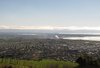
 Auckland City Webcam
View from a silo over Auckland City including The Viaduct Event centre, Sky Tower and Auckland's Waterfront area.
Auckland City Webcam
View from a silo over Auckland City including The Viaduct Event centre, Sky Tower and Auckland's Waterfront area.
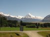 Glentanner Webcam
View from Glentanner Park Centre overlooking Lake Pukaki towards Aoraki Mount Cook. Updates every 10 mins. Thanks to Glentanner Park.
Glentanner Webcam
View from Glentanner Park Centre overlooking Lake Pukaki towards Aoraki Mount Cook. Updates every 10 mins. Thanks to Glentanner Park.
 Greymouth Webcam
Greymouth township and river mouth. Thanks to the Greymouth Rotary Club. Updates every 10 minutes.
Greymouth Webcam
Greymouth township and river mouth. Thanks to the Greymouth Rotary Club. Updates every 10 minutes.
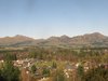 Hanmer Springs Webcam
South over Hanmer Springs township and Leslie Hills from Conical Hill. Updates every half hour - spectacular in winter.
Hanmer Springs Webcam
South over Hanmer Springs township and Leslie Hills from Conical Hill. Updates every half hour - spectacular in winter.
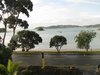
 Kaiteriteri Webcam
Overlooking Kaiteriteri Beach Great beach for swimming and boating. Many thanks to the Kaiteriteri Beach Camp.
Kaiteriteri Webcam
Overlooking Kaiteriteri Beach Great beach for swimming and boating. Many thanks to the Kaiteriteri Beach Camp.
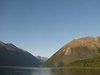 Lake Rotoiti Webcam
View from the shore of Lake Rotoiti situated in the Nelson Lakes National Park. Thanks to Tasman District Council
Lake Rotoiti Webcam
View from the shore of Lake Rotoiti situated in the Nelson Lakes National Park. Thanks to Tasman District Council
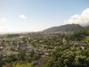
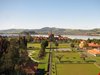
 Nelson Richmond Webcam
View over Richmond towards Tasman Bay. Many thanks to Tasman District Council.
Nelson Richmond Webcam
View over Richmond towards Tasman Bay. Many thanks to Tasman District Council.
 Paihia Webcam
A beautiful shot across the Bay towards Russell from the Pioneer Waterfront Apartments. Updates every 10 minutes.
Paihia Webcam
A beautiful shot across the Bay towards Russell from the Pioneer Waterfront Apartments. Updates every 10 minutes.
 Rotorua District Council Webcam
Overlooking the Government Gardens and the famous Bath House of Rotorua. Thanks to Rotorua District Council.
Rotorua District Council Webcam
Overlooking the Government Gardens and the famous Bath House of Rotorua. Thanks to Rotorua District Council.
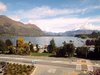 Wanaka Webcam
Overlooking the beautiful Lake Wanaka from the offices of Prime Wanaka.
Wanaka Webcam
Overlooking the beautiful Lake Wanaka from the offices of Prime Wanaka.